The start of 2020 is bringing yet another flood watch for the Lake Erie Shoreline including Erie Shore Drive and the high bluff areas.
The Lower Thames Valley Conservation Authority (LTVCA) issued the watch late Wednesday morning due to high winds in the forecast.
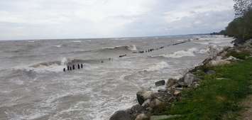
According to the LTVCA, powerful winds that have hit the area over the last few days are expected to pick up again later in the day Wednesday.
"Forecasts suggest that winds will pick up again and could exceed 35 km/hr sometime [Wednesday] afternoon. Forecasts suggest that winds would then stay between 30 and 40 km/hr through the overnight period and all day Thursday," the LTCVA said in a press release.
Waves are also predicted to reach up to 2-metres in height during this period. In addition, there is a risk that wave action could damage shoreline protection works and cause erosion all along the Lake Erie shoreline in Chatham-Kent and Elgin County.
As they continue to monitor the situation, the LTVCA is reminding residents to pay close attention to weather conditions.
"People should take extra caution and avoid the shoreline should conditions get rough. The waves can be strong and the shoreline slippery. There could also be hazardous debris within the waves and water that could be thrown onto the shore. Standing water can also present unseen hazards."
The watch is in effect until Friday.


