Get ready for a wet start to the weekend if you have some waterfront property.
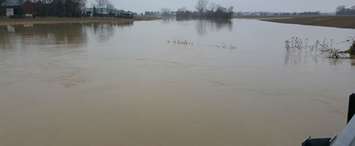
The Lower Thames Valley Conservation Authority (LTVCA) issued a flood outlook statement Friday morning, warning residents that the combination of a "significant amount of rainfall over the next 24 hours" mixed with warmer temperatures and melting snow could lead to some ponding and localized flooding in areas with poor drainage.
Officials with the LTVCA said forecasters are expecting anywhere between 15 to 25 millimetres of precipitation over the next 24 hours, which will cause local ditches, creeks, and streams to start rising later today.
The LTVCA is also expecting that the rainfall combined with melting snow upstream is expected to produce enough runoff that they will need to operate the McGregor Creek Diversion Channel.
The statement from the LTVCA said residents can reduce nuisance flooding by clearing catch basins and other drainage areas. You should also stay away from the water's edge for the time being because the banks are slippery and the water is cold and moving quickly.


