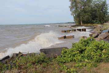
Properties along Erie Shore Drive may be hit with flooding as strong wind gusts over the next 24 hours are expected to create powerful waves on Lake Erie.
The Lower Thames Valley Conservation Authority (LTVCA) issued a flood watch on Saturday for Erie Shore Drive and the Lake Erie shoreline.
Conservation officials said sustained wind speeds of up to 35 kilometres per hour are expected to start Saturday evening and last throughout the day Sunday.
During peak winds, wave height of up to 1 metres should be expected on Lake Erie. Forecasts also suggest there is a risk of thundershowers beginning Saturday evening, which could bring periods of stronger waves and wind.
"Due to high lake levels, there is a risk that wave action could damage shoreline protection works and cause erosion all along the Lake Erie shoreline in Chatham-Kent and Elgin County, including along the high bluff areas," the conservation authority said in a media release. "Given the forecasts for wind speeds in the 25 km/hr to 35 km/hr range from a generally southerly direction, there is a risk of flooding along Erie Shore Drive in Chatham-Kent. There would also be some risk of flooding in other south-facing shoreline communities along Lake Erie."
Residents are reminded to avoid the shoreline to ensure their safety.
The flood watch is expected to remain in effect until Monday.