Windy weather over the Thanksgiving long weekend has prompted a flood watch for areas along the Rondeau Bay and Lake Erie shorelines.
The Lower Thames Valley Conservation Authority (LTVCA) issued a flood watch on Friday afternoon as a strong wind warning is currently in effect for western Lake Erie.
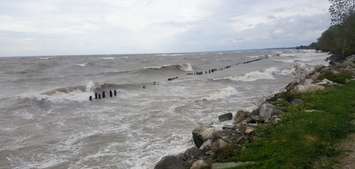
Conservation officials said wind speeds are expected to become stronger overnight, with gusts over 60 kilometres per hour. Wind direction is also expected to change by Saturday morning to the southwest.
By Saturday evening, winds are expected to switch to a northeast direction with gusts up to 50 km/h.
The windy weather could last until Monday.
"Wave forecasts for Lake Erie are generally calling for waves of around 1 to 1.5 metres in the nearshore areas and with possibly 2 to 3 m waves on the open lake during the overnight period [Friday]," read a release from the LTVCA.
Flooding is expected on Erie Shore Drive. The area was already hit with flooding earlier this week as it was under a flood warning.
Conservations officials said there is also a chance that flooding will occur in the Rondeau Bay communities of Shrewsbury and on the bay side of Erieau.
This weekend's windy conditions are not expected to affect areas along the Lake St. Clair shoreline, within the LTVCA's jurisdiction.
A flood watch will remain in effect until October 13.


