Residents are reminded to use caution around the Lake Erie shoreline as heavy winds are forecasted over the next 24 hours.
On Sunday morning, the Lower Thames Valley Conservation Authority (LTVCA) issued a flood watch for the Lake Erie shoreline and Erie Shore Drive.
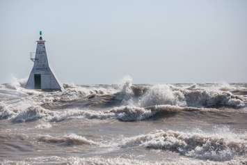
"Forecasts are predicting that winds will pick up this afternoon and switch to the south. Overnight, winds are predicted to switch to the southwest. Down on Lake Erie, sustained wind speeds could reach 35 kilometres an hour by early this evening," stated a release from the LTVCA.
Winds are predicted to peak overnight and could reach anywhere between 40 and 60 kilometres an hour. As a result, wave heights on the lake could peak at over 2 metres in height in nearshore areas and 3 metres on the open water.
Strong winds are then predicted to continue into Monday morning, switching to the west and dropping off in the late morning.
"Due to high lake levels, there is a risk that wave action could damage shoreline protection works and cause erosion all along the Lake Erie shoreline in Chatham-Kent and Elgin County, including along the high bluff areas," said the LTVCA.
The flood watch is in effect until Monday.


