Strong wind gusts expected over the next couple of days could cause some flooding for several areas in Chatham-Kent and Essex County.
The Lower Thames Valley Conservation Authority (LTVCA) issued a flood watch on Wednesday evening for the communities of Shrewsbury, Erieau, Rose Beach Line, Wheatley, and Lighthouse Cove.
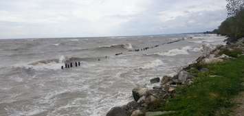
The Essex Region Conservation Authority (ERCA) also issued a shoreline conditions statement for the Lake St. Clair and Lake Erie shorelines, including Pelee Island. Although the current lake levels and wind conditions don't quite reach the flood watch threshold, ERCA said there is some risk of flooding along the Great Lakes' shorelines.
Conservation officials will continue to monitor weather conditions. Environment Canada issued a gale warning for western Lake Erie in anticipation of windy weather expected to start Thursday morning. Winds are expected to become stronger throughout the day, with gusts up to 65 kilometres per hour by Thursday afternoon. There may also be some light rain on Thursday.
The strong wind gusts are expected to continue into Friday morning from a northeast direction. However, windy conditions are expected to calm down by Friday afternoon.
The LTVCA said weather conditions are expected to create waves up to two metres in height on Lake Erie in nearshore areas and three metres in height offshore.
"Northeast winds predicted for Thursday through into Friday morning could produce flooding in the southwest corner of Rondeau Bay and impact the communities of Shrewsbury and the bay side of Erieau," read a release from the LTVCA. "At the lower end of the predicted wind speeds, very limited flooding would be expected in these communities, whereas if the gale force winds appear more widespread flooding should be expected."
The conservation authority is not anticipating significant flooding along Erie Shore Drive.Area such as Lighthouse Cove may experience some flooding late Thursday evening into Friday morning, however, if winds stay out of the northeast, flooding is not anticipated.
"The northeast winds will be offshore or along shore for most of the Lake Erie shoreline and this means there is generally a lower risk that wave action could damage shoreline protection works and cause shoreline erosion than might be expected for such a wind event," read and LTVCA release. "However, east facing shorelines, such as the areas around Rose Beach Line and Wheatley, are more vulnerable to such winds."
The St. Clair Region Conservation Authority also issued a safety bulletin on Wednesday as a low pressure system out of Colorado is expected to cause large waves along the southern Lake Huron shoreline.Both the LTVCA and ERCA are asking residents to avoid areas along the shoreline over the next couple of days as conditions may be slippery.
The flood watch issued by the LTVCA will be in effect until Saturday.


