Strong winds could cause some damage along the Lake Erie shoreline on Thursday, says the Lower Thames Valley Conservation Authority.
The local conservation authority issued a flood outlook statement following the predictions of strong winds forecasted to start overnight Wednesday.
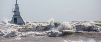
Sustained wind speeds are forecasted to peak around 40-45 km/hour early Thursday morning with gusts up to 65 km/hour and diminish in the afternoon.
"The marine forecast suggests south winds are to peak around 45 km/hour over the lake overnight and then veer southwesterly around 45 km/hour in the morning before diminishing later Thursday," the LTVCA said. "Waves in open water areas are forecasted to reach 1.5 metres in height early Thursday morning."
There is a risk of flooding and shoreline damage along Erie Shore Drive overnight and Thursday morning.
“The wind speeds and directions in the forecasts have caused significant flooding in the area over the last few years and water levels are currently fairly close to where they were at this time last year,” the LTVCA added.
Residents in the area should pay close attention to local conditions and be prepared.
There could also be impacts on other low-lying shoreline areas that have seen flooding in recent years.