With precipitation and strong winds expected to last through Saturday, the St. Clair Region Conservation Authority says communities near Lake St. Clair and Lake Huron should prepare for minor flooding along the shoreline.
A low-pressure system moving across Ontario is expected to bring some exceptional winter weather to the region.
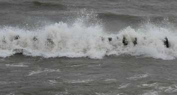
Winds could reach up to 100 kilometres per hour over Lake St. Clair. The conservation authority anticipates waves up to two metres high starting mid-day Friday. With the added storm surge, water levels could elevate quickly and lead to minor flooding near the shoreline and natural floodplains.
"Residents along the Lake St. Clair shoreline near Mitchell’s Bay and Walpole Island First Nation should pay close attention to local conditions," said Water Resources Specialist Emily De Cloet in a statement. "Water levels in the Sydenham River at Wallaceburg may also become elevated due to backflow from strong winds."
"Strong winds over Lake Huron are also anticipated to bring storm surge, increased wave action and freezing spray. Waves are anticipated to be around [three] metres during this event and water levels may be elevated," she said.
With such powerful waves, shoreline erosion is a possibility along Lake St. Clair and Lake Huron, according to the conservation authority.
The public is advised to stay far away from the shoreline and flooded areas to avoid dangerous conditions.


