Strong winds in the forecast for Wednesday have prompted the Lower Thames Valley Conservation Authority to issue a flood outlook.
There is currently a special weather statement in effect for Chatham-Kent due to forecasts of strong winds, gusting to near 80 km/h, late Wednesday morning until late Wednesday afternoon.
Forecasters are calling for southerly winds to rise overnight with sustained wind speeds that could reach 40 to 45 km/h.
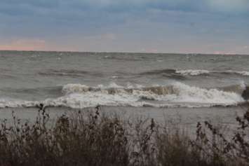
"Winds are predicted to switch more southwest during the day and peak wind speeds of 45 to 50 km/h, with gusts as high as 80 km/h, could be seen in the afternoon," read a statement from the LTVCA." The ice on Lake Erie has mostly melted away and the lake is now open throughout the LTVCA jurisdiction."
Wave forecasts for Lake Erie suggest wave heights of 1 to 1.5 metres.
According to officials, temperatures are predicted to stay above freezing throughout this event and while Lake Erie water levels dropped quite a bit in the latter half of 2022, they have been rising since the beginning of the year and are nearly back up to where they were at this time last year.
"Based on these weather forecasts, there is some risk of minor flooding along Erie Shore Drive in Chatham-Kent late overnight and throughout the day Wednesday," the statement said. "These higher wind speeds in the forecast have the potential to create waves that could cause minor flooding to properties in the area."
Flooding is likely to be limited to the rear yards of homes with some accumulation in the front yards.
"It is unlikely that water would accumulate enough to make it onto the roadway," the statement said. "Residents should monitor local conditions and be prepared."
Winds are not predicted to cause issues on the Lake St. Clair shoreline in the LTVCA jurisdiction.


