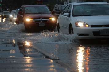
After a heavy rainstorm swept the region on Friday and Saturday, the St. Clair River Conservation Authority (SCRCA) warns that a number of roadways have been impacted by flooding.
Forecasts originally called for 20 to 45 millimetres of rainfall over the two-day period, prompting the conservation authority to issue a flood outlook statement.
The storm ended up bringing significantly more precipitation than expected - somewhere between 60 and 70 mm. This led SCRCA to upgrade their warning to a flood watch.
Water levels rose quickly causing minor flooding across the watershed including floodplain areas, parks and fields, and several roads.
Drivers are advised that the following roads have been impacted by flooding:
• Stanley Line between Kimball Road and Waubuno Road (CLOSED).
• Waubuno Road from Petrolia Line to Rokeby Line (CLOSED).
• Pretty Road north of McCallum Line.
• Waterworks Road north of Courtright Line.
• Telfer Road between Courtright Line and Moore Line.
The public is reminded that watercourses and flooded surfaces are dangerous due to slippery banks and cold, moving water. The conservation authority urges that children and pets should be kept away from these areas.
SCRCA will continue to monitor watershed conditions and provides updates to the flood watch if necessary.
The message will remain in effect until Monday at noon unless otherwise noted.


