The Lower Thames Conservation Authority has issued a flood outlook ahead of the windy weather in Sunday's forecast.
Forecasts are predicting winds will switch to the southwest as they pick up Sunday afternoon, with sustained winds speeds reaching up to 45 km/h by Sunday evening.
"While some forecasts suggest a lessening of winds overnight, others are calling for winds to remain strong and forecasts for Monday during the day and evening suggest sustained wind speeds of 35 to 45 km/h.," said conservation officials in the flood outlook . "Wind gusts of 50 to 60 km/h are predicted as well, with the possibility of stronger gusts at times."
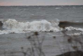
The wind on Monday evening is predicted to switch more westerly and to drop off overnight. Wave forecasts for Lake Erie suggest wave heights of 1 to 1.5 m in shoreline areas.
"Based on these weather forecasts, there is some risk of flooding along Erie Shore Drive in Chatham-Kent from this evening through Monday," said the LTVCA. "Although recent flooding along the road has been isolated during recent events, lake levels have now risen back up above where they were at this time year in 2021 and 2022."
Due to high lake levels and wave conditions, there is also a risk that wave action could damage shoreline protection works and cause erosion all along the Lake Erie shoreline in Chatham-Kent and Elgin County, including along the high bluff areas.
Winds are not predicted to cause issues on the Lake St. Clair shoreline in the LTVCA jurisdiction.


