The Lake Erie shoreline could see damage and erosion over the weekend.
On Saturday, the Lower Thames Valley Conservation Authority (LTVCA) issued a combined Shoreline Condition Statement and Flood Outlook.
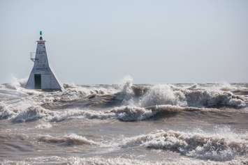
There is currently a Gale Warning and a Freezing Spray Warning in effect from Environment Canada, as forecasts predict strong southwest winds to batter the shore from late Saturday evening to late Sunday afternoon.
The winds are expected to go from a sustained 40 kilometres per hour to 50 km/h with gusts over 65 km/h. "Wave forecasts suggest wave heights up to 3 m on the open waters of Lake Erie and waves up to 2 m could be seen in nearshore areas," the LTVCA said in a release.
Based on these weather forecasts, there is a risk of minor flooding along Erie Shore Drive in Chatham-Kent. "Any water making it to the roadway could lead to slippery conditions on the road. Residents in the area should monitor local conditions and be prepared," the release said.
Due to high lake levels and wave conditions, there is also some risk that wave action could damage shoreline protection works and cause erosion even in the high bluff areas.
Winds are not predicted to cause issues along the Lake St. Clair shoreline in the LTVCA jurisdiction.
People and animals are advised to take extra caution and avoid the shoreline, as waves can be strong and the shoreline could be slippery and icy.


