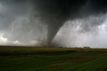
Some residents of the London area watched the skies, while others headed for their basements, as a tornado warning was issued on Friday afternoon.
Environment Canada issued the warning just before 1:35 p.m. as forecasters tracked a storm that they said was possibly producing a tornado. At 1:35, the storm was located near Arva, moving southeast at 40 km/h. An update was provided by Environment Canada at 1:45, saying the storm was near London, moving southeast at 60 km/h and headed toward Dorchester, Nilestown and Putnam.
By 2:11 p.m., the warning had been lifted, but forecasters warned the storm was still capable of producing strong winds, hail, and heavy rain.
Londoners and those living outside the city took to social media to share their pictures and videos.
Mi primer alerta de tornado y esa cosa estaba bien cerca... #TORNADOWARNING #ldnont #ontstorm pic.twitter.com/pqFK4dhXU1
— Sir Mireille Pasos of Lesbiville ?️??️ (@pasos_m) July 19, 2019
Funnel cloud spotted in London, Ontario near Adelaide and Commissioners area facing North. #ldnont #TORNADOWARNING
Credit: Nicky Birk pic.twitter.com/v6FklE3Jrk— Gary Zee (@gaz2002) July 19, 2019
Some hail in Dorchester #ldnont #ONStorm pic.twitter.com/BiTcONt55g
— Michael Mullis (@MT_MikeMullis) July 19, 2019
A time lapse of the #ONStorm from a downtown view in #ldnont pic.twitter.com/2Oou0nSjTV
— Pat L. (@ThatPatL) July 19, 2019
Stay safe #ldnont ! This is looking north on Wonderland at 1:33 PM right before the tornado alert came in #onstorm #staysafe pic.twitter.com/wXBSMbE9us
— MmeJMacKinlay (@MmeJMacKinlay) July 19, 2019