It's going to be a snowy start to the weekend for those in the London region.
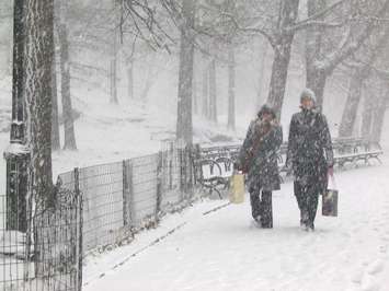
After the storm system that dumped 12 centimetres of snow on the area earlier this week, snow squalls are now threatening to drop another 20 centimetres of the white stuff by Saturday afternoon.
Environment Canada issued a snow squall watch for London, Middlesex County, and Oxford County Friday morning and upgraded it to a snow squall warning for London and Eastern Middlesex in the evening.
"The winds over Lake Huron are going to shift more northwesterly later [Friday] evening and that is when the chance of snow squalls will begin," said Environment Canada Meteorologist David Rogers. "Right now it is looking like a local five-10 centimetres of snow Friday night and another five-10 centimetres on Saturday morning."
Environment Canada added that some areas may see up to 25 centimetres of snowfall overnight.
If the squalls do materialize, driving could become hazardous due to sudden reduced visibility and quickly accumulating snow. People in the area are advised to consider changing any travel plans accordingly.
Any snow that does fall won't be sticking around for very long though, according to Rogers.
"Probably Friday and Saturday are our coldest days and then it is going to gradually warm-up," said Rogers. "We are probably looking at a high of plus 5 C and rain on Monday."
While the mild weather is expected to stick around throughout next week, Rogers cautions it doesn't mean spring has arrived.
"That next cold snap is never too far away," said Rogers. "We are just in that season where winter battles spring and eventually spring wins, but for quite awhile it is a bit of a battle."
The normal average daytime high for this time of year is 1 C.


