The images posted to social media were right, a tornado did touch down in northeast London on Tuesday afternoon.
A survey team from Western University's Northern Tornadoes Project (NTP) has confirmed an EF0 with estimated maximum wind speeds of 115 km/h formed near the London International Airport just after 2:30 p.m.
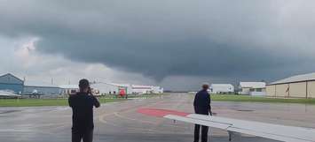
It was shortly before that, video of a funnel cloud taken from the airport began making the rounds on social media.
The survey team was sent to the area on Wednesday morning. It found a path of weak tree damage and was able to determine a twister did touch down. The length of the damage path and the maximum width still need to be determined.
"Further investigation is pending, including track analysis and satellite imagery review," NTP indicated in a tweet.
Southwestern Ontario has been experiencing hot, humid weather since Sunday, which prompted Environment Canada to issue a heat warning a half hour before the tornado formed. Sweltering temperatures are known to make conditions ripe for the development of severe thunderstorms which can spawn twisters.
An EF0 is the lowest rating on the Enhanced Fujita (EF) Scale, which goes up to EF5.
Anyone who has additional photos or video of the tornado or any damage left in its wake is encouraged to email Environment Canada at [email protected].
Video of tornado east of London Airport moments ago. #onstorm #onw @StormhunterTWN @westernuNTP pic.twitter.com/Ty88oN7uUO
— Nicholas (@Planechuter) August 10, 2021