The Goderich area was a hotbed of tornadic activity Saturday with three twisters confirmed to have hit within the span of a hour.
Western University's Northern Tornadoes Project (NTP) confirmed the appearance of the tornadoes after conducting a full ground and drone survey of the area. Researchers determined the tornadoes were produced by a supercell thunderstorm, appearing between 6:30 p.m. and 7:30 p.m.
The first was a waterspout over Lake Huron about 14 kilometres northwest of Bayfield. Witnesses captured numerous photos and video of the event. It caused no damage and was assigned a default EF0 rating.
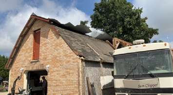
Less than half an hour later as the supercell re-intensified over land it produced an EF0 tornado north of Porter's Hill. Researchers determined it had an estimated maximum wind speed of 125 kilometres an hour and travelled 6.24 kilometres with a path width of 190 metres. The roof of a barn was peeled back and a coverall building and trees were also damaged.
The same supercell thunderstorm then spawned a new area of rotation, and by 7:30 p.m. a third tornado near Harlock. This twister had an estimated maximum wind speed of 90 kilometres an hour and tracked 4.68 kilometres in length with a width path of 330 metres, researchers said. It was given an EF0 rating with just tree and crop damaged found.
None of the three tornadoes resulted in any injuries.
EF0 is the weakest rating on the enhanced Fujita scale.
Confirmation of the trio of twisters came a day after the Northern Tornadoes Project classified a downburst that hit Mitchell last Thursday as an EF1. It caused damage to several barns, utility poles, trees, and crops in the area.