The arrival of a sharp cold front just before noon Friday prompted the St. Clair Region Conservation Authority (SCRCA) to post a flood watch for the Lake Huron shoreline.
The conservation authority said strong north-northwesterly winds with gusts upwards of 55 kilometres per hour are anticipated Friday, subsiding in the evening and overnight before resuming Saturday and Sunday.
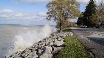
Wind-driven waves of one to one-and-a-half metres are expected, with possible erosion and minor flooding, particularly in the Old Lakeshore Road area of Bright's Grove.
SCRCA said roads along the shoreline may have to be closed.
Residents are reminded to avoid shorelines and flooded areas due to slippery banks and cold, swift-moving water.
The watch will remain in effect until June 1, unless otherwise updated.
Hot, muggy weather that prompted a heat warning this week ended abruptly with the arrival of a cold front Friday. Winds shifted northerly and the temperature that had risen to 22 C by 11 a.m. at Chris Hadfield Airport, dropped to 15 C by 1 p.m.


