The Ausable Bayfield Conservation Authority has issued a flood watch for Sunday into Monday and Tuesday.
The authority said a large low-pressure system and cold front will move into southern Ontario Sunday bringing strong northwest winds and lake effect snow to the Lake Huron shoreline.
Sustained winds of up to 60 kilometres per hour will develop with peak gusts of 70 to 100 kilometres per hour Sunday night into Monday morning.
Winds are expected to diminish through the day Tuesday.
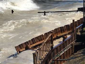
The authority said strong winds, combined with near record-high water levels on Lake Huron, will result in higher than normal waves hitting shoreline areas for a prolonged period of time.
Residents are reminded to stay well back from breaking waves and from top-of-bluff areas in case there has been any movement of the lake bank.


