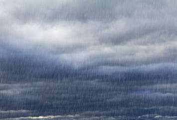
This weekend will bring a mixed bag of weather as mild temperatures and thunderstorms are possible before a cold front and gusty winds swoop in.
Environment Canada issued a special weather statement Thursday afternoon for most of southwestern Ontario, including Sarnia-Lambton. Up to 45 millimeters of rain and wind gusts of up to 90 kilometers per hour are possible, starting Friday night into Saturday night.
The weather statement was upgraded Friday afternoon to a wind and rainfall warning. However, the rainfall warning ended Saturday morning and the wind warning ended Saturday evening.
Warning Preparedness Meteorologist Peter Kimbell said gusty winds will especially be felt in areas near Lake Huron.
"The peak period for wind would likely be Saturday afternoon, after the passage of a cold front. We actually are looking for a fair amount of rain [Friday night] and possibly [Saturday] morning with a chance of thunderstorms," he said.
Although thunderstorms are "a bit abnormal" to have in December, Kimbell said it has happened before.
As the heavy rainfall starts to taper off, temperatures are expected to be quite mild. Kimbell said temperatures are expected to rise to 12 Celsius (54 Fahrenheit) by Saturday morning. However, a cold front is forecast to move in Saturday afternoon, resulting in gusty winds into the evening hours.
"With the cold from [Saturday] afternoon the temperatures should fall and we might even see some snow late in the day, with temperatures falling below 0 C [Saturday] night," said Kimbell. "Then we bounce back up above 0 C again Sunday and Monday as well."
Next week's warm air mass is expected to last for a few days as Wednesday's high will be 11 C (52 F). However, gusty winds are also expected next week, which may prompt another special weather statement.
Environment Canada said this weekend's weather could cause local power outages and loose objects to be tossed.
A gale warning has also been issued for the St. Clair watershed.
The St. Clair Region Conservation Authority (SCRCA) said a combination of heavy rainfall, saturated and unfrozen soil and rising water levels may cause minor flooding and impact some roads this weekend.
The SCRCA and Ausable Bayfield Conservation Authority issued a flood outlook Friday afternoon as conservation officials continue to monitor watershed conditions.
Residents are reminded to avoid shorelines, watercourses and flooded areas due to slippery conditions and fast moving cold water.


