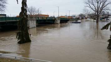
With warmer temperatures and rainfall expected this weekend, the local conservation authority is warning of possible flooding.
The Lower Thames Conservation Authority said the 15 to 20 millimetres of rain forecasted for Saturday night may cause local ditches, creeks and streams to rise and spill their banks. To make matters worse, the snowpack in the west of the Lower Thames watershed will likely melt due to spring-like temperatures, which will likely result in another 10 millimetres of water.
Conservation officials said the ice jam that formed in February has mostly dissipated, however, recent freezing temperatures have added about 5 to 10 centimetres of new ice on the Thames River. As a result, blockages of ice, snow and debris could also cause localized flooding on smaller watercourses.
Water levels should be expected to remain high into early next week.
Residents are advised to take extra caution and avoid the river, ditches, and streams as the combination of slippery banks, unstable ice and fast moving cold water can be dangerous.
Environment Canada has also issued a special weather statement for the rainfall. In addition to the rain, they're also forecasting southwest winds gusting up to 80 km/h throughout Sunday.


