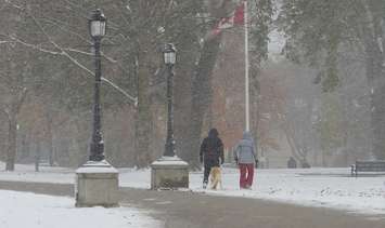
It was a snowy wake-up for many across southwestern Ontario Monday after the region received its first taste of winter weather.
Total snowfall amounts were much lower inside the City of London than the 15cm Environment Canada had said may be possible. The London International Airport recorded just 5 cm as of Monday morning.
However, areas to the west and north of the city, such as Strathroy and Grand Bend, received roughly 10 cm as a snow squall parked itself over those spots for most of the night.
"The [snowfall] amounts did very a fair bit," said Environment Canada Meteorologist Brian Owsiak. "London did have a couple heavy bursts early Sunday night. But for the most part the heaviest squall set up to the west of the city overnight. So that is good news for the people living in the city itself."
Environment Canada issued the first snow squall warning of the season for London-Middlesex, Sarnia-Lambton, Grey-Bruce, and Huron-Perth around 9 p.m. Sunday. Heavy snow squalls developed off Lake Huron and Georgian Bay and were forecast to dump up to 15 cm of snow.
A weather advisory was also issued for Woodstock, Tillsonburg, and Oxford County.
The wintry weather left Highway 402 between London and Sarnia icy Monday morning. Other secondary roads were said to be snow covered or slushy.
The November 1 snow squalls caught many off guard with people flooding social media with images of the falling flakes.
"It's not unheard of, but it is a bit unusual to have a snow squall warning issued at the start of November," said Owsiak. "We've had unseasonably cool temperatures for the last ten days. So it isn't impossible, but I don't think it is typical for this early in the season."
For those who would rather not deal with the white stuff, Owsiak said it won't be on the ground for long.
"Once we get through Monday the weather pattern changes quite a bit. We go from below seasonal to above seasonal temperatures after Tuesday. We flip into a warmer pattern and that taste of winter will be gone," said Owsiak. "I am sure people will appreciate the warmer temperatures coming up."
Double-digit temperatures are expected to arrive Tuesday and last through the weekend with daytime highs reaching 16 C both Saturday and Sunday.