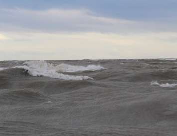
Strong northwest winds will again create flooding and erosion problems along the Lake Huron shoreline
A large low-pressure system will move across Lake Huron on Wednesday bringing strong winds with gusts exceeding 70 kilometres per hour.
The powerful winds are expected to begin early Wednesday morning and persist through the day, before diminishing in the evening.
The strong winds, combined with near record-high water levels on Lake Huron, will result in higher than normal waves hitting shoreline areas. Freezing spray is expected to create dangerous walking conditions along the shoreline and may accumulate on low-lying structures.
In addition to flooding of low-lying coastal areas, continued erosion of the lakeshore bluff is likely. Residents and municipal officials are reminded to stay well back from breaking waves, and also to stay away from top-of-bluff areas during and after the storm
The Ausable Bayfield Conservation Authorities has issued a flood watch, while Maitland Valley Conservation has issued a flood warning for the lakeshore. Updates will be provided as needed.
Wind speeds are forecasted to be below those observed during the strongest storms earlier this fall, however, the duration of this event could approach 24 hours. Waves are expected to build through the early morning tomorrow before subsiding overnight into Thursday.