Residents across the Ausable Bayfield and Grand River watersheds are being warned of potential flooding and ice jams as a low-pressure system moves through the region this week.
The system is expected to bring 15 to 25 mm of rain between Tuesday, March 4, and Wednesday, March 5, alongside above-freezing temperatures reaching up to 10°C in some areas.
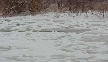
According to the Ausable Bayfield Conservation Authority (ABCA) and the Grand River Conservation Authority (GRCA), the recent cold winter has resulted in thick river ice and a heavy snowpack, which will rapidly thaw under the forecasted conditions. With streams already elevated, officials warn of localized flooding in low-lying areas, road closures, and heightened risks of ice jams.
ABCA Snow survey data from February 28 shows the water equivalent in the current snowpack ranges between 46-82 mm. This puts most locations above the typical snow water equivalent of 50 mm for this time of year.
With the breakup of river ice, the risk of ice jams and sudden flooding is particularly high in flood-prone areas such as the lower Ausable River between Ailsa Craig and Port Franks, the Bayfield River, and along the Grand River system. Municipal flood coordinators have been advised to monitor historically affected areas and prepare to implement their flood response plans if necessary.
Residents in flood-prone areas are urged to stay prepared, as water levels can rise suddenly and without warning. Authorities recommend reviewing local flood response programs and taking precautionary measures to protect property and personal safety.
While GRCA reservoirs remain within their normal operating range and have flood storage capacity available, authorities stress that conditions can change rapidly.
Officials from both conservation authorities are urging the public to stay away from waterways, as fast-moving water, unstable ice, and slippery streambanks pose significant hazards. All ice on local rivers and streams should be considered unsafe.
This flood outlook remains in effect until Monday, March 10 at 9 a.m., unless conditions change. Both conservation authorities will continue to monitor conditions and issue updates as needed.