Fall will start off a little warmer than usual, before returning to more seasonal temperatures.
The autumnal equinox officially arrives at 2:19 p.m. Monday, September 22.
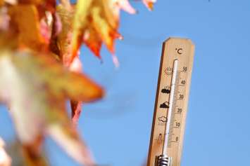
Environment Canada Meteorologist Crawford Luke said the warm trend we've seen last week will likely continue a little big longer.
"It looks like the final half of September is probably going to be warmer than normal to start the fall season," said Luke. "But we're not really seeing a really strong signal for the fall as an entire season for it to be a warmer than normal fall the whole time. So I'm sure we'll get some shots of cold air eventually, after this current warm spell that we're in."
Luke said fall is the time of year we typically see temperatures change the fastest
"So we normally cool down faster in the fall than we warm up in the spring," he said. "For September typically our daytime high on average is around 22 C, overnight lows of 11 C. Then when we move to October, typically the daytime high is 15 C with a low of 6 C and when we get to November, typically our daytime high is 8 C with an overnight low of 0 C."
Luke said the drier than usual weather for Sarnia is expected continue for the rest of the month as well.
With an more typical fall season for the region, Luke said it's likely we will see some snow before winter officially arrives.
"I would say it's actually normal to see some snow by the end of the fall season," he said. "And again, with Lake Huron right there it's just a matter of getting some cold air over the lake to set up the lake effect, and have it be cold enough for it to fall as snow instead of rain."
Historically on average, Luke said Sarnia receives about seven centimetres of snow during the month of November.
"October is kind of hit or miss, but we have seen snow in October before," he said.


