Strong winds in the forecast have prompted the local conservation authority to issue a flood watch for the Lake Erie Shoreline and the Detroit River shoreline.
The watch was issued late Saturday morning by the Essex Region Conservation Authority (ERCA). Current forecasts are predicting strong winds out of the east through Saturday afternoon with sustained speeds reaching 30 km/hr. By early Sunday morning, winds are predicted to be at speeds between 40 and 50 km/hr out of the south, shifting southwest, and eventually west.
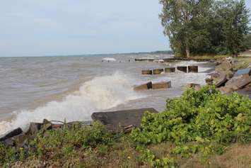
"There is a potential for winds out of the east to elevate lake levels in the western basin of Lake Erie and the Detroit River," ERCA said in a press release. "The potential areas most significantly impacted along the Lake Erie shoreline due to the easterly winds are the southeast shoreline of the Municipality of Leamington between Wheatley Harbour and the tip of Point Pelee, and the eastern shoreline of Pelee Island."
According to ERCA, high winds could cause waves on Lake Erie to reach as high as 1.5 metres in some areas. On Sunday, the potential areas most likely to be significantly impacted are the south and west shorelines of Pelee Island, the shoreline of the Municipality of Leamington and the shorelines of the Towns of Kingsville, Essex and Amherstburg.
In addition to the predicted wind, there is also a significant amount of rain in the forecast, with 30-40 mm potentially arriving by early Saturday evening.
The watch is in effect until Tuesday morning. People are reminded to use extra caution and avoid areas where flooding is occurring.


