During Chatham-Kent's council meeting on December 15, mayor and council unanimously voted to enter into agreements to obtain four locations along Talbot Trail to aid in the Talbot Trail Realignment.
The locations include 0.02 acres at 2953 Talbot Trail, 1.62 acres at 2961 Talbot Trail, 2.52 acres at 3021 Talbot Trail, and 0.08 acres at 3089 Talbot Trail.
Council also approved a contract amendment of $621,500.00 (including HST) with AECOM Canada Ltd. to complete the Stage 4 Archaeological Assessment for the Talbot Trail Realignment project, as well as a contract amendment of $282,500.00 (including HST) with EXP Services for First Nations fieldwork participation.
***December 12 CKNewsToday.ca article updated on December 16***
--
The reopening of Talbot Trail could take some important next steps soon if Chatham-Kent Council approves the purchase of four parcels of land.
Council is being asked to approve buying a total of 4.24 acres of land at 2953, 2961, 3021, and 3089 Talbot Trail, totalling approximately $235,200, to move forward with the realignment of Talbot Trail.
"Municipal Staff have negotiated with adjacent property owners for the lands required to construct the realignment of the roadway to reopen Talbot Trail. Legal Services has drafted Agreements of Purchase and Sale, which the property owners of the above parcels have accepted," staff wrote in a report going to Council on Monday night.
Council is also being asked to approve another $621,500 for the Stage 4 Archaeological Assessment for the Talbot Trail Realignment project and $282,500 for the First Nations Fieldwork Participation because more archaeological work was needed on a larger-than-anticipated area of land.
"The volume of findings [artifacts] encountered within the project area was above and beyond what could have been anticipated at the time of the project award or following the completion of the Stage 2 and 3 Archaeological Assessments," staff stated.
Staff also said there is a risk that further archaeological findings may be uncovered during construction, and that would cost more money.
According to staff, there has been no indication that burials exist within the project area, but warns that if human remains are encountered, there would be cost and schedule implications beyond what has been projected.
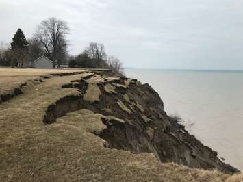
In July 2019, a portion of Talbot Trail from Coatsworth Road to approximately 800 meters east of Coatsworth Road was closed due to erosion of the bluff along Lake Erie and the risk of slope and road failure.
Council has adopted an Interim Solution to relocate Talbot Trail outside of the 30-year hazard zone and allow the roadway to be reopened while further planning could be completed for the Long-Range Solution. The Interim Solution relocates Talbot Trail to the northwest of its existing alignment between Coatsworth Road and 3089 Talbot Trail.
The Long-Range Technically Preferred Alternative is to construct a new two-lane rural arterial road from Ellerbeck Road to Stevenson Road, following the existing 2nd Concession Line. This involves significant improvements to 2nd Concession Line, along with road re-alignment requirements at Campbell Road and Coatsworth Road.
The realignment of Talbot Trail is expected to be complete before the end of 2026.
The original estimate for the project was $7.2 million, but it's now up to $8.1 million, and staff warn that it could be higher.
According to staff, approximately $1.6 million has been spent to date, including costs related to detailed design, land appraisal, tree removals, and Archaeological Assessments.